


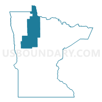
Beltrami, Becker, Hubbard, Clearwater, Mahnomen & Lake of the Woods Counties PUMA, Minnesota
About
Outline

Summary
| Unique Area Identifier | 193208 |
| Name | Beltrami, Becker, Hubbard, Clearwater, Mahnomen & Lake of the Woods Counties PUMA |
| State | Minnesota |
| Area (square miles) | 8,887.81 |
| Land Area (square miles) | 7,600.50 |
| Water Area (square miles) | 1,287.31 |
| % of Land Area | 85.52 |
| % of Water Area | 14.48 |
| Latitude of the Internal Point | 47.77658510 |
| Longtitude of the Internal Point | -95.15263800 |
Maps

Graphs
Select a template below for downloading or customizing gragh for Beltrami, Becker, Hubbard, Clearwater, Mahnomen & Lake of the Woods Counties PUMA, Minnesota


Neighbors
Neighoring Public Use Microdata Area (by Name) Neighboring Public Use Microdata Area on the Map
- Clay, Polk, Roseau, Pennington, Marshall, Norman, Kittson & Red Lake Counties PUMA, MN
- Crow Wing, Morrison, Todd & Wadena Counties PUMA, MN
- Itasca, Carlton (South), Cass & Aitkin Counties--Grand Rapids City PUMA, MN
- St. Louis (North), Koochiching, Lake & Cook Counties--Hibbing & Cloquet Cities PUMA, MN
- West Central Minnesota PUMA, MN
Top 10 Neighboring County (by Population) Neighboring County on the Map
- Clay County, MN (58,999)
- Otter Tail County, MN (57,303)
- Itasca County, MN (45,058)
- Beltrami County, MN (44,442)
- Becker County, MN (32,504)
- Polk County, MN (31,600)
- Cass County, MN (28,567)
- Hubbard County, MN (20,428)
- Roseau County, MN (15,629)
- Pennington County, MN (13,930)
Top 10 Neighboring County Subdivision (by Population) Neighboring County Subdivision on the Map
- Bemidji city, Beltrami County, MN (13,431)
- Detroit Lakes city, Becker County, MN (8,569)
- Lower Red Lake UT, Beltrami County, MN (5,790)
- Northern township, Beltrami County, MN (4,657)
- Park Rapids city, Hubbard County, MN (3,709)
- Bemidji township, Beltrami County, MN (3,134)
- Lake township, Roseau County, MN (2,090)
- Detroit township, Becker County, MN (2,033)
- Grant Valley township, Beltrami County, MN (2,029)
- Warroad city, Roseau County, MN (1,781)
Top 10 Neighboring Place (by Population) Neighboring Place on the Map
- Bemidji city, MN (13,431)
- Detroit Lakes city, MN (8,569)
- Park Rapids city, MN (3,709)
- Warroad city, MN (1,781)
- Red Lake CDP, MN (1,731)
- Bagley city, MN (1,392)
- Frazee city, MN (1,350)
- Redby CDP, MN (1,334)
- Mahnomen city, MN (1,214)
- Little Rock CDP, MN (1,208)
Top 10 Neighboring Unified School District (by Population) Neighboring Unified School District on the Map
- Bemidji Public School District, MN (36,502)
- Grand Rapids Public School District, MN (27,545)
- Detroit Lakes Public School District, MN (16,612)
- Park Rapids Public School District, MN (12,088)
- Perham Public School District, MN (10,315)
- Pelican Rapids Public School District, MN (7,434)
- Pine River-Backus Public School District, MN (7,315)
- Walker-Hackensack-Akeley School District, MN (7,092)
- Frazee-Vergas Public School District, MN (6,964)
- Roseau Public School District, MN (6,728)
Top 10 Neighboring State Legislative District Lower Chamber (by Population) Neighboring State Legislative District Lower Chamber on the Map
- State House District 9A, MN (42,418)
- State House District 4B, MN (41,669)
- State House District 2B, MN (39,744)
- State House District 4A, MN (39,479)
- State House District 9B, MN (39,347)
- State House District 10B, MN (37,598)
- State House District 2A, MN (37,063)
- State House District 10A, MN (35,993)
- State House District 3A, MN (35,316)
- State House District 1A, MN (35,146)
Top 10 Neighboring State Legislative District Upper Chamber (by Population) Neighboring State Legislative District Upper Chamber on the Map
- State Senate District 9, MN (81,765)
- State Senate District 4, MN (81,148)
- State Senate District 2, MN (76,807)
- State Senate District 3, MN (73,721)
- State Senate District 10, MN (73,591)
- State Senate District 1, MN (71,334)
Top 10 Neighboring 111th Congressional District (by Population) Neighboring 111th Congressional District on the Map
Top 10 Neighboring Census Tract (by Population) Neighboring Census Tract on the Map
- Census Tract 4502, Beltrami County, MN (6,514)
- Census Tract 4501, Beltrami County, MN (6,246)
- Census Tract 9400.01, Beltrami County, MN (5,885)
- Census Tract 302.01, Clay County, MN (5,631)
- Census Tract 4507.02, Beltrami County, MN (5,233)
- Census Tract 4506, Beltrami County, MN (5,179)
- Census Tract 4503, Becker County, MN (4,962)
- Census Tract 701, Hubbard County, MN (4,711)
- Census Tract 302.02, Clay County, MN (4,528)
- Census Tract 9607, Cass County, MN (4,426)
Top 10 Neighboring 5-Digit ZIP Code Tabulation Area (by Population) Neighboring 5-Digit ZIP Code Tabulation Area on the Map
- 56601, MN (32,225)
- 56501, MN (16,290)
- 56470, MN (10,334)
- 56573, MN (5,993)
- 56751, MN (5,575)
- 56572, MN (5,454)
- 56544, MN (5,294)
- 56763, MN (5,180)
- 56621, MN (4,639)
- 56633, MN (4,541)